-

MASTERPLAN
-
JUSTIFICATION
-
MAIN PROBLEM
-
HYDROLOGICAL STUDIES
-
DESIGN PROCESS
-
INFRASTRUCTURE PUBLIC SPACE
-
PROJECT SECTION
-
PANEL
Resilience Strategies
Gerardo García Fuentevilla, Marcelo Adrián Hernández Páez, Luis Javier Laffitte Armesto. Monterrey, Mexico
-
Name of work in English
Resilience Strategies
-
Name of work in original language
Public Space as river infrastructure
Prize year
Young Talent 2020
-
Work Location
Monterrey, Mexico
-
Author/s
Gerardo García Fuentevilla, Marcelo Adrián Hernández Páez, Luis Javier Laffitte Armesto
-
School
School of Architecture and Habitat Science - Universidad de Monterrey.
Monterrey, Mexico
Young Talent 2020 YT Open Nominees


Resilience Strategies
Public Space as river infrastructure
Program
Mixed use - Infrastructure & Urban
-
Labels
Aggregation · Master plan · Public Space · Regeneration · Waterfront
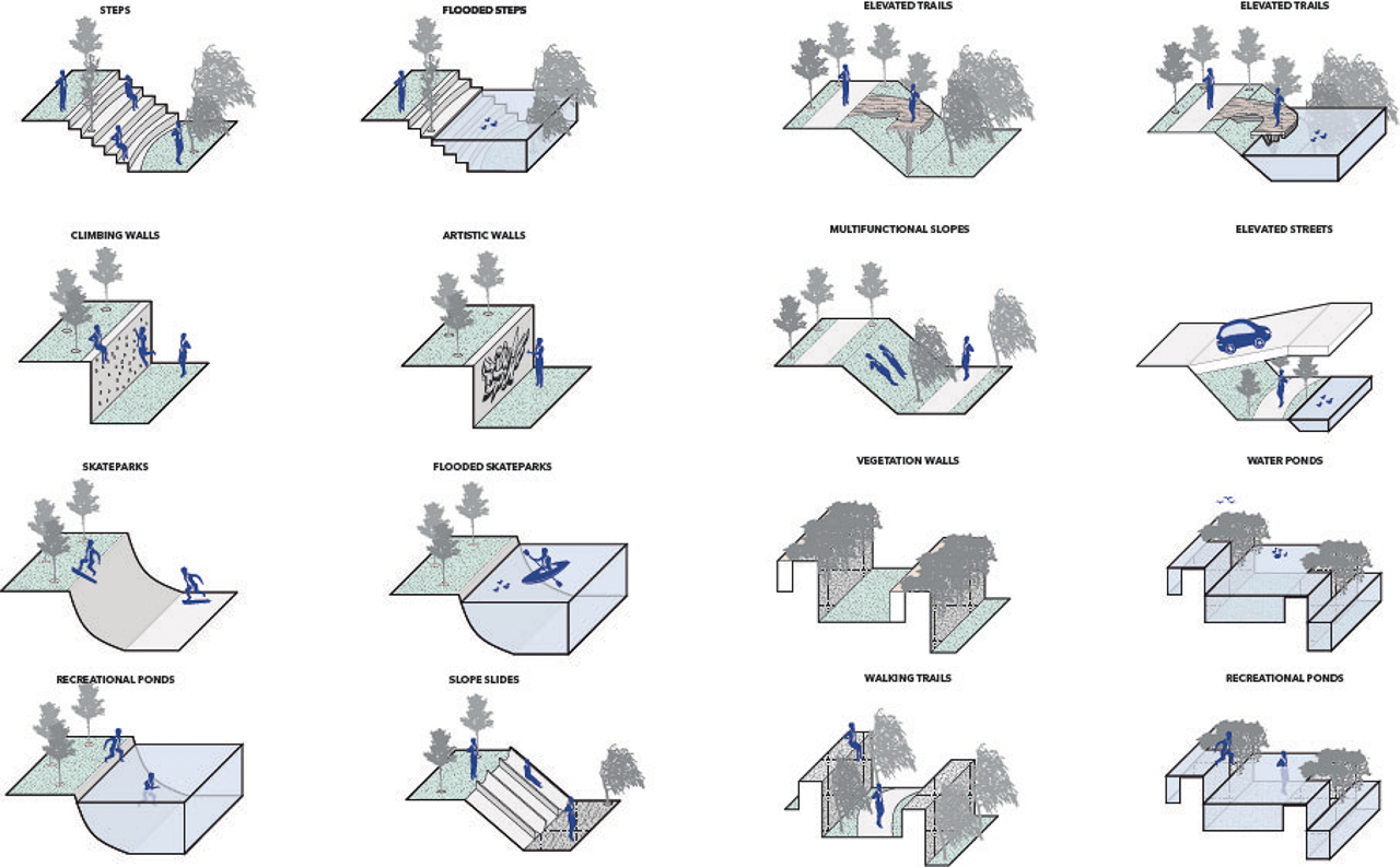
Monterrey is a city surrounded by hills. When it rains they have water runoff that go down natural elements called river gullies. These runoffs slide superficially through the streets causing flood conflicts. This project approaches the problem by generating public space as river infrastructure.
All the information analyzed in the research process is synthesized in the design of the CTC (Cerro del Topo Chico) linear park 02 located in Escobedo, one of the poorest neighborhoods of Monterrey. This linear park is developed in an integral way through an urban-landscape program that incorporates public space as a governing element over urban infrastructure, and also, over river infrastructure. The longitudinal extension of the project is of 750 meters approximately, starting at the foot of the Topo Chico hill until the boundaries of the Pesquería river. Throughout this extension, even cross-sectionally, there are elements of river infrastructure aimed at reducing the site's vulnerability to surface runoff and floods that, previously and frequently, have deteriorated the neighborhoods adjacent to the ravine. The fluvial infrastructure matrix includes wetlands, rain gardens, spaces for absorption, rain gutters in streets, channel speed bumps, water retention ponds; all these implemented as urban equipment within the public space. These elements are incorporated into and out of the ravine that unfolds linearly until it reaches the river. The ravine fulfills this infrastructural functionality by itself since it has a safety buffer, which protects users from floods in rainy seasons. The park's program consists of spaces for different users, so they try to integrate activities of different kinds in themselves, encouraging the coexistence of neighbors and inhabitants near the river gorge. These spaces include recreation areas, green areas, sports fields, playgrounds, skate parks, cultural and artistic spaces, urban gardens, viewpoints, a pet area, forums, squares, and pedestrian streets, among others. Finally, the park meets the need for neighborhood integration through the implementation of pedestrian streets that cross the ravine. These streets add, in addition to an urban and landscape beautification, urban equipment and river infrastructure to redirect surface runoff flows to the natural stream.